The most famous trail in northern Spain
Some trails are done for the scenery. Some are done for the summit. And then there is the Cares Route: a trail done for the path itself.
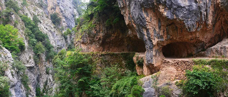
Eleven kilometres of track carved into raw limestone, suspended halfway between the Cares river — roaring 500 metres below — and the summits of the central massif of the Picos de Europa. No summit to conquer, no brutal climb to endure. The spectacle is the path itself: an impossible ledge that zigzags between semi-tunnel galleries, bridges over the void and vertical walls up to 1,000 metres high.
More than 100,000 people walk the Cares Gorge every summer season. It is the most visited trail in Picos de Europa National Park and one of the most walked in all of Spain. But doing it well — at the right time, with the right gear and knowing what to expect — makes the difference between a memorable experience and an uncomfortable walk in the middle of a crowd.
This is the guide we wish we had had before going.
The history of the path
The Cares Gorge was not built for hikers. It was built to maintain a water canal.
Between 1916 and 1921, the electricity company Electra de Viesgo carved an 11 km canal along the gorge to divert the waters of the Cares river and feed a hydroelectric power station at Camarmeña. The canal runs partly through tunnels blasted in the rock and partly in the open. The path alongside it — built so workers could travel the full length of the canal — is the track that hundreds of thousands of people now walk every year.
The accidental result of that feat of engineering is one of the most spectacular trails in the world. And the canal is still working.
The route step by step
Starting point: Poncebos
The vast majority of hikers start at Poncebos, in the Cabrales valley (Asturias). This is the northern end of the gorge and the most accessible: there is a car park (paid in season) reached via the AS-264 road from Arenas de Cabrales.
From Poncebos, the path crosses the Cares river on a bridge and enters the gorge almost immediately. Within the first few metres the surroundings are already breathtaking: the river drops rapidly far below and the limestone walls begin to close in around the path.
The Puente de los Rebecos
Roughly halfway along the route, the path crosses the river on the Puente de los Rebecos (Chamois Bridge), a narrow bridge over the Cares that allows hikers to switch banks. It is the best point to photograph the gorge from below.
The chamois that give the bridge its name are regular visitors on the limestone ledges above the path. Walk slowly and quietly and you have a good chance of spotting them.
La Jenduda: the standout moment
The most spectacular point of the entire route is La Jenduda, where the gorge narrows to its minimum and the path becomes a semi-tunnel gallery carved directly into the rock. Vertical walls rise sheer for hundreds of metres on both sides. This is where most hikers stop, look up, and understand what this place is about.
End point: Caín
The southern end of the Cares Gorge is the village of Caín, in the province of León. It is a small cluster of houses perched at the start of the gorge on the Leonese side, with a bar where you can celebrate your arrival.
From Caín you can return to Poncebos on the same path (the full round trip is 22 km) or arrange a taxi back to the start.
Everything you need to know before you go
When to go?
The route is walkable from May to October. The best month is June: the path is less crowded than in July and August, the vegetation is at its most lush, and chamois descend to lower altitudes.
In July and August the heat in the gorge can be intense (the limestone walls absorb heat) and crowds are at their peak. If you go in high season, arrive at Poncebos before 8:00 am. After 10:00 the path can be so busy that comfortable walking becomes difficult.
In winter the road to Poncebos may be closed by snow or ice.
What footwear to wear?
The path is uneven stone for the full 11 km. Trainers are not recommended: a single damp section is enough to make them a source of slips. Trekking boots with stiff soles are the right choice.
How much water to carry?
There are no water sources anywhere on the route. Carry at least 1.5 litres per person in summer. The gorge can be surprisingly hot.
How to get back from Caín?
You have three options:
- Walk back along the same path (22 km total, approximately 6 hours of walking).
- Hire a taxi from Caín back to Poncebos or Arenas de Cabrales. Taxis are available in the village.
- Pre-arranged transport: some tour operators offer transfers between Poncebos and Caín for hikers.
What else to see nearby?
- Bulnes village: 1.5 hours on foot from Poncebos via a steep path, this roadless village is one of the most singular in Asturias.
- Arenas de Cabrales: the nearest town to the start of the route, famous as the birthplace of Cabrales blue cheese.
- Covadonga and the Lakes: 40 minutes by car from Arenas, the Sanctuary and the glacial lakes are unmissable.
Guided tour: is it worth it?
If it is your first time in the Picos de Europa, booking a guided Cares Route tour has clear advantages: the guide explains the geology of the gorge, the history of the canal and the wildlife on the walls, and organises the return transport from Caín. Tours can be booked from Cangas de Onís or Arenas de Cabrales.
The self-guided version is perfectly manageable for any hiker with basic experience. The technical difficulty of the route is low; the only demands are distance and appropriate footwear.
Final thoughts
The Cares Route does not disappoint. It is one of those experiences that alone justify a trip to northern Spain. The combination of the sheer scale of the walls, the sound of the river and the engineering of the path creates something that has few rivals in European hiking.
Go early. Bring water and boots. And be prepared to understand why this path has been astonishing everyone who walks it for over a century.

