

The route
Map and profile
- Ascent790 m
- Descent34 m
- Highest1,969 m
- Lowest1,209 m
Elevation profile (one way)
Use two fingers to move the map
Track based on OpenStreetMap (© its contributors, ODbL licence); elevation from the Copernicus EU-DEM model. For guidance only: always follow the waymarks.
About the route
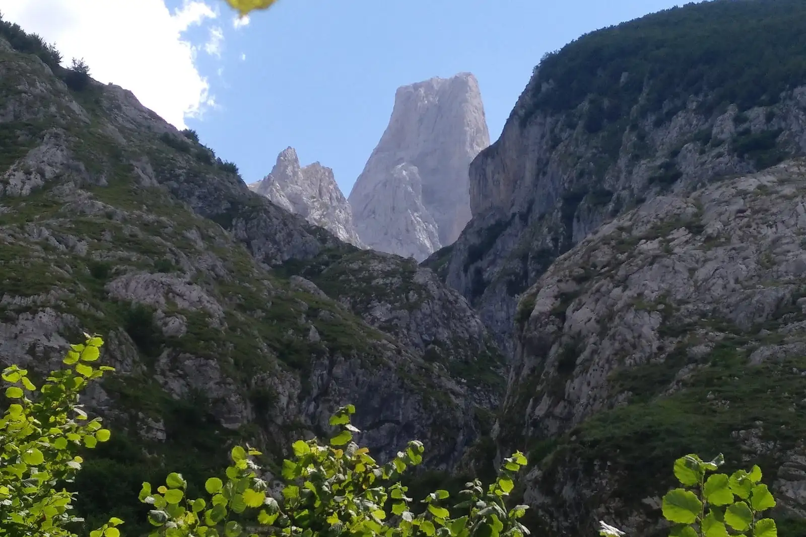
The most demanding and most iconic route in the National Park. From the Pandébano saddle, the trail climbs 900 metres to Vega Urriellu, the glacial cirque where the Naranjo de Bulnes (Picu Urriellu) stands — a 2,519 m limestone monolith and the symbol of Spanish alpinism.
Route Description
The Naranjo de Bulnes, known in Asturian as Picu Urriellu, is the most famous and most photographed peak in Spain. Its summit was first reached in 1904 (by Pedro Pidal and Gregorio Pérez, “el Cainejo”), and its western face, vertical for 550 metres, was not climbed until 1962. Today it is the playground of Europe’s top rock climbers. This route does not climb the Naranjo, but takes you to its base to experience it at close range.
The most common starting point is Pandébano (1,219 m), a saddle reachable from Sotres by 4x4 or on foot in 1 hour. From Pandébano, the path climbs to the La Terenosa sheepfold and the Collado Vallejo, and from there continues the long ascent to the cirque. The terrain grows progressively rougher: the last kilometre before the cirque is a steep climb over limestone slabs that requires using hands in places.
Arriving at Vega Urriellu (1,953 m) is one of the most striking moments in Spanish mountain hiking. The glacial cirque opens suddenly and the Naranjo looms overhead, its walls scored with cracks and often animated by climbers working their way up classic routes.
There is a mountain refuge at the cirque with food service and overnight accommodation (reservations needed in high season).
💡 Practical Tips
- Fitness level: This is a high-mountain route requiring good physical condition and stiff-soled trekking boots. The last 200 m of elevation gain are very steep over loose rock.
- Weather: The central massif changes rapidly. Check the forecast before you go and carry a waterproof even in sunshine.
- Water: There is a spring at Vega Urriellu next to the refuge.
- Overnight stays: The Urriellu refuge has limited bunks. Book months in advance in high season if you want to stay overnight and catch the Naranjo at dawn.
- Alternative approach: From Poncebos (or from Bulnes, going up by funicular) you can also reach Vega Urriellu via the Canal de Camburero, but it is a very difficult route: about 1,700 m of elevation gain and 5.5 h of climbing from Poncebos. For experienced mountaineers only.
📸 Key Highlights
- The first view of the Naranjo as you step into Vega Urriellu.
- Chamois grazing all around the cirque, completely unfazed by hikers.
- Rock climbers visible on the west face with the naked eye.
- The west face of Picu Urriellu seen up close from the cirque.
Route
Waypoints
Guided experiences
Guided tours

Booked on GetYourGuide; each activity shows its cancellation policy.
Where to stay
Accommodation in Picos de Europa
Keep exploring


