

The route
Map and profile
- Ascent534 m
- Descent356 m
- Highest557 m
- Lowest304 m
Elevation profile (one way)
Use two fingers to move the map
Track based on OpenStreetMap (© its contributors, ODbL licence); elevation from the Copernicus EU-DEM model. For guidance only: always follow the waymarks.
About the route
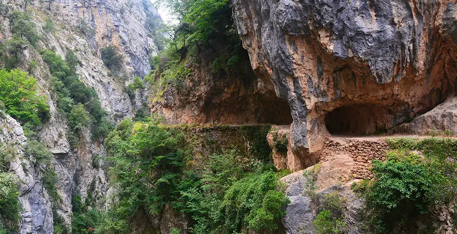
The Cares Gorge trail is the most famous route in northern Spain. Eleven kilometres of path carved into limestone rock, suspended between vertical walls up to 1,000 m high, following the canal built between 1916 and 1921 to supply the Camarmeña hydroelectric power station.
Route Description
The Cares Route is not a typical mountain trail: there is no summit to conquer, no punishing climb. Its spectacle lies in the path itself. For 11 km, the track runs along a ledge carved into limestone, halfway between the Cares river — roaring far below — and the summits of the central massif of the Picos de Europa.
The path was built between 1916 and 1921 to give maintenance access to the canal feeding the Camarmeña power station. The accidental result was a feat of engineering that today is the most visited trail in the National Park, walked by thousands of people every summer.
The route starts at Poncebos (Asturias) and ends at Caín (León). The first stretch passes through chestnut and oak woodland that soon gives way to bare rock. As the gorge narrows, the sound of the river becomes omnipresent even though the water is barely visible. Chamois are a regular sight on the limestone ledges above the path.
The highlight is the tunnels carved into the rock near Caín, where the wall is almost vertical and the path becomes a semi-tunnel gallery. The view from here along both ends of the gorge is absolutely unforgettable.
💡 Practical Tips
- Start early: In July and August the path gets crowded before 9am. Arriving at Poncebos before 8am guarantees peace and better light for photography.
- Footwear: Stiff-soled boots — the entire path is uneven stone. Trainers are not recommended.
- Water: There are no water sources on the route. Carry at least 1.5 litres per person.
- Return: Many walkers arrange a taxi from Caín to avoid the return journey on the same path.
- Season: May to October. In winter there may be ice in the tunnels and snow can block the road to Poncebos.
📸 Key Highlights
- The Puente de los Rebecos over the Cares river, halfway along the route.
- The semi-tunnel galleries carved into the limestone.
- The Puente Bolín, one of the bridges crossing the Cares on the stretch near Caín.
- The vertical walls of the central massif seen from Caín.
Route
Waypoints
Guided experiences
Guided tours

Booked on GetYourGuide; each activity shows its cancellation policy.
Where to stay
Accommodation in Picos de Europa
Keep exploring

