

The route
Map and profile
- Ascent514 m
- Descent399 m
- Highest1,388 m
- Lowest993 m
Elevation profile
Use two fingers to move the map
Track based on OpenStreetMap (© its contributors, ODbL licence); elevation from the Copernicus EU-DEM model. For guidance only: always follow the waymarks.
About the route
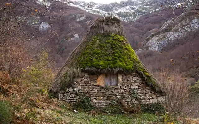
Ethnographic tour par excellence. It begins in the village of Arbeyales, climbs the La Güérgola gorge and continues along the hillside to Saliencia, passing through beautiful brañas and waterfalls that show the traditional architecture of the Teitos in all its splendor.
Route Description
The Route of the Brañas de Saliencia (PR.AS-12) is a journey to the heart of vaqueiro culture. The trail starts from Arbeyales and climbs a steep cobbled path up the La Güérgola gorge, alongside a stream with numerous waterfalls, before leaving the river and continuing across the hillside on a track between brañas.
Along the way, we will visit groups of teito (vegetable roof) cabins such as the Braña de Ordiales and the Mortera de Saliencia, living examples of human adaptation to the environment. The route ends in the town of Saliencia, completing a journey that combines nature and ethnographic heritage.
It is a perfect option to get to know the traditional Someda architecture without the overcrowding of other better-known routes.
Recommendations
With 350 m of accumulated elevation gain over 8 km, sturdy hiking boots with good grip and enough water are advisable, as the route begins with a steep cobbled climb up the La Güérgola gorge before continuing across the hillside and descending to Saliencia. Since this is a mid-mountain route, it’s best to avoid the months with heavier snow in the higher brañas and to check the weather forecast before setting out.
Route
Waypoints
Guided experiences
Guided tours


Booked on GetYourGuide; each activity shows its cancellation policy.
Where to stay
Accommodation in Somiedo




The full Somiedo guide
Somiedo has its own website, with more detail than fits here:
Keep exploring


